|
|
| |
|
tony.north |
 General Member General Member |

|
 Czech Republic
 |
| |
| Joined: 2/12/2015 |
|
Posts: 11 |
| |
|
| |
| Posted: Wednesday, March 4, 2015 at
10:02:57 AM |
IP Logged |
|
Hi, please help. For me is not running National Map Viewer :( on http://viewer.nationalmap.gov/viewer/ (still "loading"...).
Can anyone generate GeoTIFF for this location?
1) 50.8618875N 14.2689692E
2) 50.8569603N 14.2836517E
I wanna try modeling my home 9-hole course for my playing in TW08.
I´m czech, so sorry for my english.
If you can send me this, please do it to my mail adress: martinix06@gmail.com
I have some free geoTIFF of czech republic (complet CZ area), but i don´t know, how i must set this coordinates to export file to UTM for use in TA.
Thanx to all, who can help me. |
| |
| |
|
|
| |
|


|
| |
|
Gunpower61 |
 Site Admin Site Admin |
|
|
 Belgium
 |
| |
| Joined: 12/9/2004 |
|
B-Day: 4/30/1961 (62) |
|
Posts: 4,120 |
| |
|
| |
| Posted: Wednesday, March 4, 2015 at
11:02:37 AM |
IP Logged |
|
Hello, i am not an expert, maybe a course designer can give you better info, but i think you can find some help here:
http://www.coursedownloads.com/forum/posts.asp?post=9505&forum=14 |
| |
| |
|
|
| |
|
|
|
| |
|
tony.north |
|
General Member |
|
|
|
Czech Republic |
| |
| Joined: 2/12/2015 |
|
Posts: 11 |
| |
|
| |
| Posted: Tuesday, March 10, 2015 at
3:07:42 AM |
IP Logged |
|
Thank you so much, but relief detail is not too detailed and accurate. There isnt geotiff with orthophoto layer too.
Any other idea or help? |
| |
| |
|
|
| |
|
|
|
| |
|
Jimbo63 |
|
General Member |
|
|
 England
 |
| |
| Joined: 3/21/2009 |
|
B-Day: 7/30/1947 (76) |
|
Posts: 591 |
| |
|
| |
| Posted: Tuesday, March 10, 2015 at
11:50:25 AM |
IP Logged |
|
I used to use this
http://www.coursedownloads.com/forum/posts.asp?post=8124&forum=14
then Google changed things and I could not get it to work. It was never very accurate data (90m I think). The USGS site is good for USA courses, but the rest of the world is not very good.
Try this site for SRTM
http://dds.cr.usgs.gov/srtm/version2_1/SRTM3/
but again I think it is only 90m.
Good luck with your project |
| |
| |
|
|
| |
|
|
|
| |
|
tony.north |
|
General Member |
|
|
|
Czech Republic |
| |
| Joined: 2/12/2015 |
|
Posts: 11 |
| |
|
| |
| Posted: Tuesday, March 17, 2015 at
6:25:41 AM |
IP Logged |
|
| edited by: tony.north on
Tuesday, March 17, 2015 at
7:00:00 AM
- |
| |
Thanx :) How can I use only a part of HGT file in 3DEM? I try "select smaller area" -> "Convert to UTM projection" -> "Save Terrain Matrix" with ASCII. But TA say me "Runtime Error 7011 - Matrix Dimensions illegal at line 683" :(( and quitting.
I need .HDR file for these coordinates:
1) 50.8618875N 14.2689692E
2) 50.8569603N 14.2836517E
Can anybody send me HDR and TXT for this coordinates? (For use in TA)
And specify which format is it (10m, 30m or SRTM-3), please?
Thank so very much for your pleasure.
Mail is: martinix06@gmail.com |
| |
| |
|
|
| |
|
|
|
| |
|
Jimbo63 |
|
General Member |
|
|
|
England |
| |
| Joined: 3/21/2009 |
|
B-Day: 7/30/1947 (76) |
|
Posts: 591 |
| |
|
| |
| Posted: Tuesday, March 17, 2015 at
9:59:29 AM |
IP Logged |
|
Tony you are doing things in the wrong order in 3DEM, you are selecting a smaller shape too soon, download and read this tutorial
http://coursedownloads.com/extras/details.asp?id=719
You will also struggle to get an area accurate to so many decimal points, I could only ever manage 4 decimal points and then they were not always spot on. |
| |
| |
|
|
| |
|
|
|
| |
|
tony.north |
|
General Member |
|
|
|
Czech Republic |
| |
| Joined: 2/12/2015 |
|
Posts: 11 |
| |
|
| |
| Posted: Friday, March 20, 2015 at
3:20:33 AM |
IP Logged |
|
| Jimbo63: Very thanks for your useful help, i try it with this tutorial and write, how i´m succesful :) |
| |
| |
|
|
| |
|
|
|
| |
|
tony.north |
|
General Member |
|
|
|
Czech Republic |
| |
| Joined: 2/12/2015 |
|
Posts: 11 |
| |
|
| |
| Posted: Friday, March 20, 2015 at
4:22:15 AM |
IP Logged |
|
So... i have new coordinates:
50°51´43"N 14°16´7"E
50°51´24"N 14°17´3"E
I have coordinates from google earth, as well as foto image, converted to TGA in paint.net.
I donwnloaded file N50E014.hgt.
In 3DEM i select smaller area, change to UTM and save matrix as HDR (in attachment).
But in TA if i wanna import HDR, the app is crashing with this:
"Matrix dimensions illegal"...
Can help me? |
| |
|
|
| |
|
|
| |
|
|
|
| |
|
tony.north |
|
General Member |
|
|
|
Czech Republic |
| |
| Joined: 2/12/2015 |
|
Posts: 11 |
| |
|
| |
| Posted: Friday, March 20, 2015 at
4:07:06 PM |
IP Logged |
|
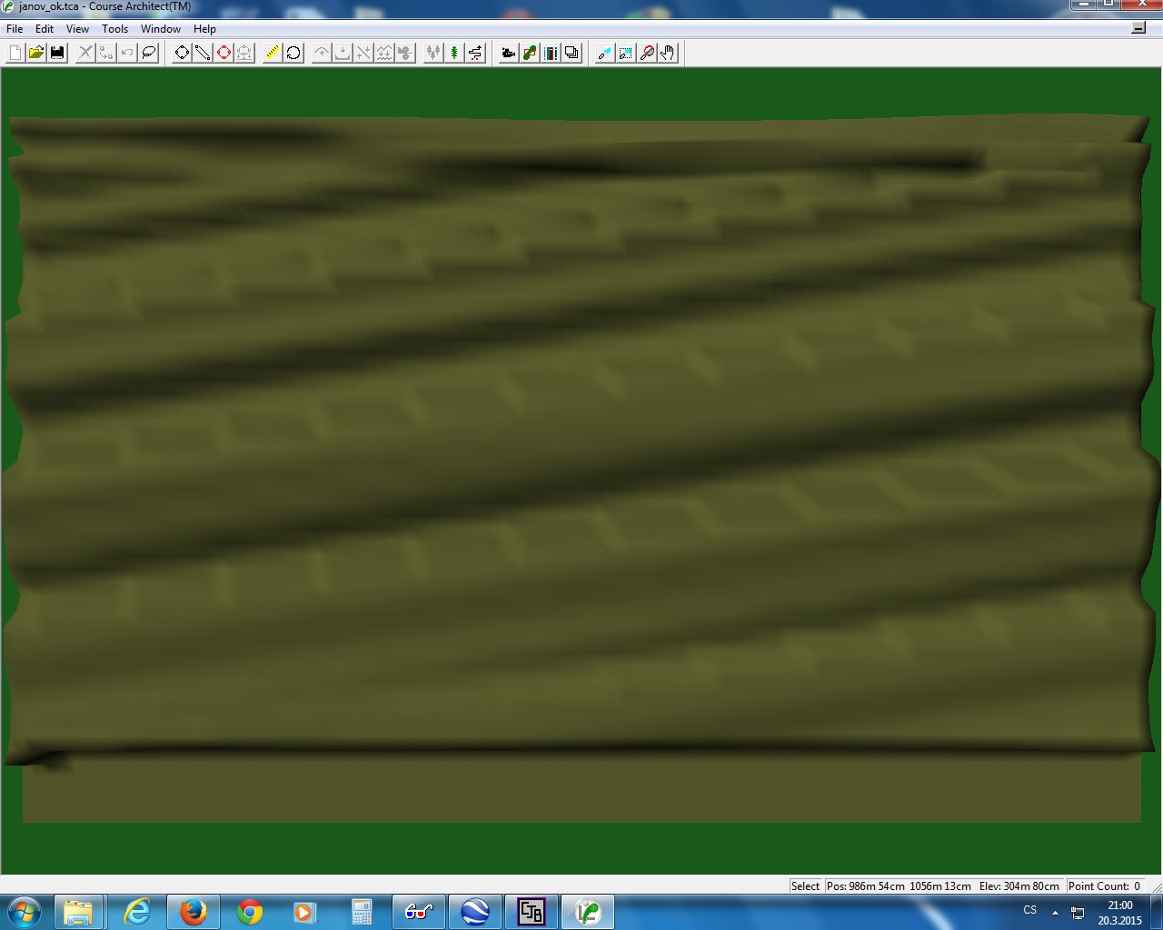
The fault was too small area i think.
Now i create area:
50°51´47"N 14°12´57"E
50°51´19"N 14°17´10"E
This is ok for import to TA. TA say: create flat plot 1560 x 980 yards exactly.
CA want dimensions in meters. So i tansfer yards to meters and dimensins are 1426 x 897 meters.
When i export 3dem to flat *.tca file (1426x897 meters), CA is falling down.
If i create flat 1560x980 meters, CA open it, but clay is very deformated.
Can help, how big i must create flat plot in meters for this area? |
| |
|
|
| |
|
|
| |
|
|
|
| |
|
Jimbo63 |
|
General Member |
|
|
|
England |
| |
| Joined: 3/21/2009 |
|
B-Day: 7/30/1947 (76) |
|
Posts: 591 |
| |
|
| |
| Posted: Friday, March 20, 2015 at
8:34:37 PM |
IP Logged |
|
Must be done in this order
Convert to UTM projection. Go to Operation=>Change Projection=>Change UTM Ellipsoid … make sure that you check NAD27 and hit OK. Go to Geo Coordinates and check Minutes of Degree (if that is what you are using). Now go to Operation=>F6 Resize Overhead View and move the slider about 2/3 of the way across. The program will take a few moments to re-render the zoomed-in image.
Go to Operation=>F8 Select Smaller Area and find the top left corner of your plot. Click at that spot and then drag to the exact
coordinates of the bottom right corner of your plot, or as near as possible. Hit enter. Now you just need to save the data. Go to File=>Save Terrain Matrix=>File Format … select ASCII Text String and hit OK. Now you have your DEM data. Open up TA and check SRTM, load the DEM and the image |
| |
| |
|
|
| |
|
|
|
| |
|
Jimbo63 |
|
General Member |
|
|
|
England |
| |
| Joined: 3/21/2009 |
|
B-Day: 7/30/1947 (76) |
|
Posts: 591 |
| |
|
| |
| Posted: Friday, March 20, 2015 at
8:38:08 PM |
IP Logged |
|
| Open Course Architect to create another plot. Once you get to the part where you can see the heading View click on it, then uncheck metres which is the bottom item. You can then recreate your plot in yards as per the request from terrain assist. |
| |
| |
|
|
| |
|
|
|
| |
|
tony.north |
|
General Member |
|
|
|
Czech Republic |
| |
| Joined: 2/12/2015 |
|
Posts: 11 |
| |
|
| |
| Posted: Saturday, March 21, 2015 at
3:55:45 AM |
IP Logged |
|
|
"Must be done in this order
Convert to UTM projection. Go to Operation=>Change Projection=>Change UTM Ellipsoid … make sure that you check NAD27 and hit OK. Go to Geo Coordinates and check Minutes of Degree (if that is what you are using). Now go to Operation=>F6 Resize Overhead View and move the slider about 2/3 of the way across. The program will take a few moments to re-render the zoomed-in image.
Go to Operation=>F8 Select Smaller Area and find the top left corner of your plot. Click at that spot and then drag to the exact
coordinates of the bottom right corner of your plot, or as near as possible. Hit enter. Now you just need to save the data. Go to File=>Save Terrain Matrix=>File Format … select ASCII Text String and hit OK. Now you have your DEM data. Open up TA and check SRTM, load the DEM and the image" |
I have inactive Change UTM Ellipsoid... in attachment... So use Convert to UTM Prjection, other steps are exactly as in tutorial... |
| |
|
|
| |
|
|
| |
|
|
|
| |
|
tony.north |
|
General Member |
|
|
|
Czech Republic |
| |
| Joined: 2/12/2015 |
|
Posts: 11 |
| |
|
| |
| Posted: Saturday, March 21, 2015 at
3:59:47 AM |
IP Logged |
|
|
| "Open Course Architect to create another plot. Once you get to the part where you can see the heading View click on it, then uncheck metres which is the bottom item. You can then recreate your plot in yards as per the request from terrain assist." |
And where i can uncheck Meters? |
| |
|
|
| |
|
|
| |
|
|
|
| |
|
tony.north |
|
General Member |
|
|
|
Czech Republic |
| |
| Joined: 2/12/2015 |
|
Posts: 11 |
| |
|
| |
| Posted: Saturday, March 21, 2015 at
4:01:55 AM |
IP Logged |
|
|
"
|
| "Open Course Architect to create another plot. Once you get to the part where you can see the heading View click on it, then uncheck metres which is the bottom item. You can then recreate your plot in yards as per the request from terrain assist." |
And where i can uncheck Meters?" |
I have it :) and try it :) |
| |
| |
|
|
| |
|
|
|
| |
|
tony.north |
|
General Member |
|
|
|
Czech Republic |
| |
| Joined: 2/12/2015 |
|
Posts: 11 |
| |
|
| |
| Posted: Saturday, March 21, 2015 at
4:17:45 AM |
IP Logged |
|
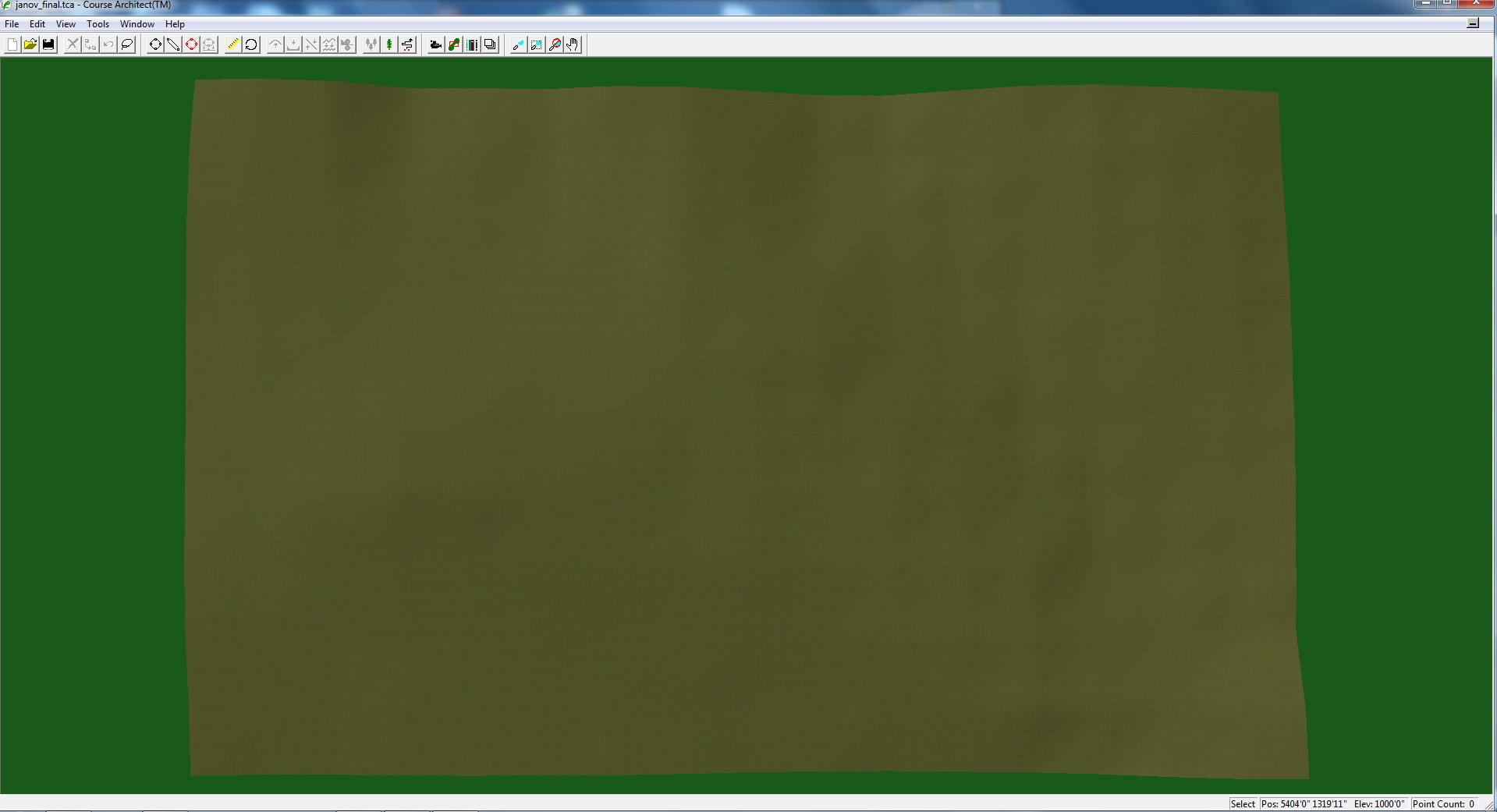
Jimbo63: I have it, very thanks for your help, in attachment is my final plot for my course.
I hope, you try my course after i finish it.
Many thanks to ypu Jimbo63 :) |
| |
|
|
| |
|
|
| |
|
|
|
| |
|
Jimbo63 |
|
General Member |
|
|
|
England |
| |
| Joined: 3/21/2009 |
|
B-Day: 7/30/1947 (76) |
|
Posts: 591 |
| |
|
| |
| Posted: Saturday, March 21, 2015 at
6:27:39 AM |
IP Logged |
|
| Good news that you got it to work. I will certainly try your course once it is completed. Happy course designing. |
| |
| |
|
|
| |
|
|
|
| |
|
Gunpower61 |
|
Site Admin |
|
|
|
Belgium |
| |
| Joined: 12/9/2004 |
|
B-Day: 4/30/1961 (62) |
|
Posts: 4,120 |
| |
|
| |
| Posted: Saturday, March 21, 2015 at
8:05:15 AM |
IP Logged |
|
| Great work guys, some interesting info in this topic, so i changed it to: Sticky topic |
| |
| |
|
|
| |
|
|
|
| |
|
tony.north |
|
General Member |
|
|
|
Czech Republic |
| |
| Joined: 2/12/2015 |
|
Posts: 11 |
| |
|
| |
| Posted: Friday, March 27, 2015 at
11:15:20 AM |
IP Logged |
|
So... designed plot looked good, but lanscape relief disagrees to relity :(
Now im in the end. Coordinates is OK, overlay image too, but relief isnt as real.
It may be that 3DEM not enough detail?
How i can modelling plot for use in CA manual? Which software is good for this?
I would like to plot modeled on the basis photomap. As i know it from relity.
This is about only way :((( |
| |
| |
|
|
| |
|
|
|
| |
|
Jimbo63 |
|
General Member |
|
|
|
England |
| |
| Joined: 3/21/2009 |
|
B-Day: 7/30/1947 (76) |
|
Posts: 591 |
| |
|
| |
| Posted: Friday, March 27, 2015 at
6:14:53 PM |
IP Logged |
|
| edited by: Jimbo63 on
Friday, March 27, 2015 at
6:18:00 PM
|
| |
| That is the problem with the height data for International courses, I have never found it to be very accurate. I presume that you are saying that it will be better to work from a flat plot. If this is how you want to do it, then still use the 3DEM material that you have but when you have drawn some shapes in Terrain Assist just export them to the flat plot that 3DEM asked you to create as it''s 3rd stage. Whatever you rename it to just keep using that plot. |
| |
| |
|
|
| |
|
|
|
 Post Reply
 New Topic